best GR trails in France
The best GR trails in France: 25 long-distance paths
The best GR trails in France: GR 20, GR 34, GR 10, Tour du Mont Blanc, the Way of St James… 25 paths, their distance, days and what makes each special.

"Best" can't be measured. What can be measured is what hikers search for and what they walk. The 25 trails below are the ones searched most on Google in France (Google Trends, five years), with the published walker counts where there are any. GR stands for grande randonnée, France's waymarked long-distance paths, red and white. At the top, unsurprisingly, are the three the French name unprompted in the FFRandonnée's survey (the French hiking federation): the GR 20, then the GR 34 and the GR 10.
We have sorted them into families: mountain crossings, tours of a massif, coastal paths, the Ways of St James and Stevenson's trail, and the great crossings of France. For each: the distance, the number of classic stages, the climbing when an official body publishes it, and what makes it special.
Mountain crossings
GR 20, Corsica from north to south
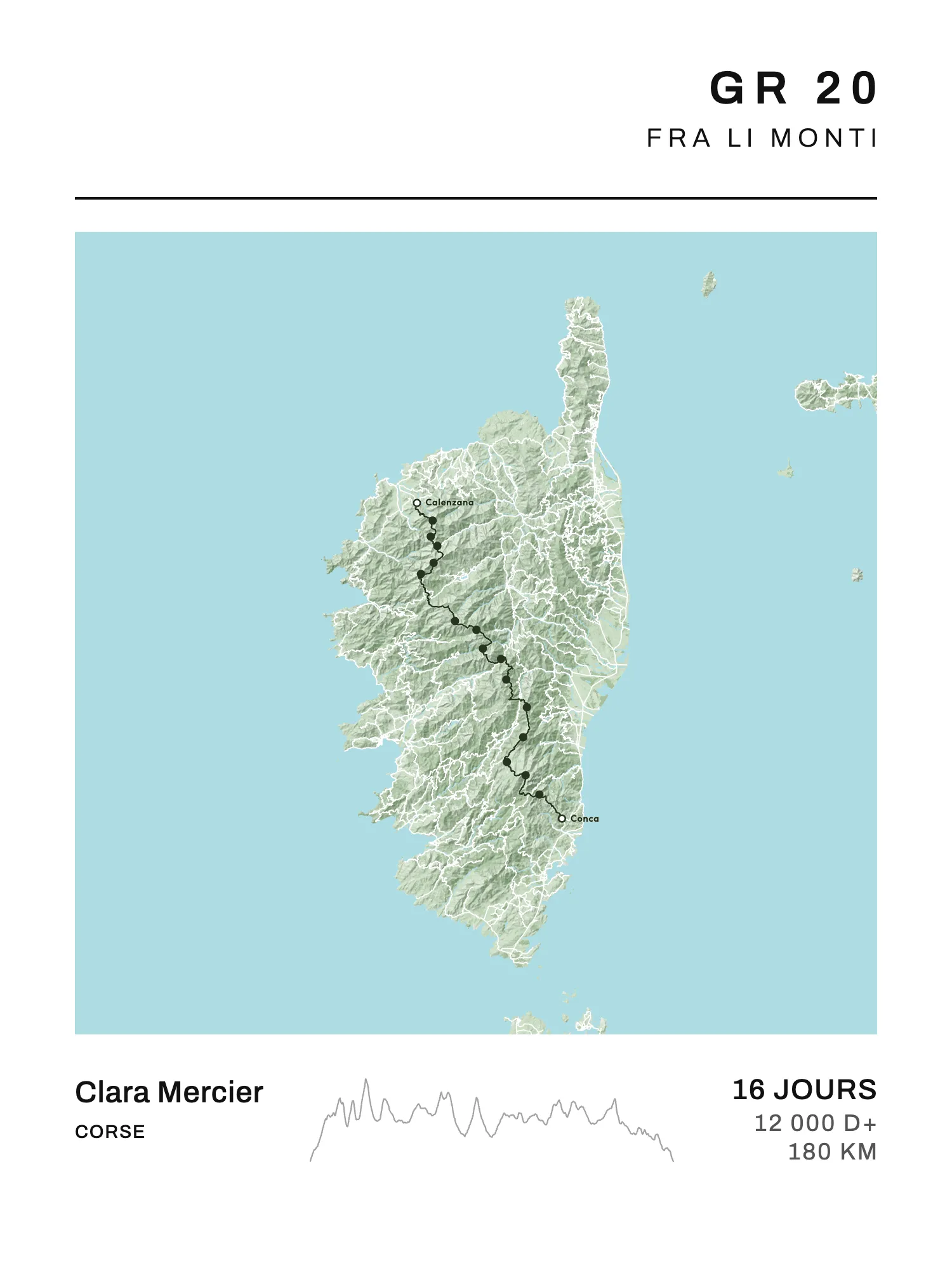
About 180 km, 12,000 m of elevation gain, 16 stages from Calenzana to Conca. The GR 20 tops out at 2,607 m at the Pointe des Éboulis, stops halfway at Vizzavona station, and you sleep only in huts or their camping areas, booked ahead. The Parc naturel régional de Corse counts nearly 20,000 hikers a season. The most famous of the GRs and, by common consent, the hardest. The stage-by-stage detail is in our GR 20 stages guide, the poster on the GR 20 page.
GR 10, across the Pyrenees
922 km and 55,000 m of climbing from Hendaye to Banyuls-sur-Mer, from the Atlantic to the Mediterranean, in 50 to 60 days according to the FFRandonnée. It crosses five départements and climbs to 2,734 m at the Hourquette d'Ossoue, below the Vignemale. Many walk it in pieces, one summer after another. See our article on the GR 10 stages and the GR 10 poster.
GR 5, the Grande Traversée des Alpes
From Lake Geneva to Nice, about 590 km on our trace in 39 stages (guides give 590 to 630 km; there is no official figure). Chablais, Mont Blanc, Vanoise, Queyras, Ubaye, Mercantour: the whole French Alps from north to south, to walk from mid-June to mid-September, once the passes are clear of snow. The full GR 5 starts at the North Sea (2,290 km); the GR 5 poster draws the Alpine part, the one everyone calls "the GR 5".
GR 738, the Haute Traversée de Belledonne
130 km and 10,000 m of climbing in 11 stages, from Aiguebelle to Vizille, hut to hut facing Grenoble. The Col de la Vache (2,556 m) is its high point. Open from 1 July to 30 September depending on snow. Quieter and wilder than its neighbours: GR 738.
GR 52, from the Mercantour to the sea
From Saint-Dalmas-de-Valdeblore, where it leaves the GR 5, to Menton, in 6 stages through the Vallée des Merveilles and its rock carvings. The highest point is close to 2,690 m at the Baisse du Basto. Our trace measures about 100 km; guidebooks give up to 99 km depending on the variants. You finish with your feet in the Mediterranean: GR 52.
GR 91, across the Vercors
78 km and 2,786 m of climbing in 6 days, from Saint-Nizier-du-Moucherotte to Châtillon-en-Diois. The second half crosses the Hauts-Plateaux du Vercors, a reserve of more than 17,000 ha with no road and no village: you sleep in unstaffed huts or in regulated bivouacs, and water is scarce. The full GR 91 carries on to Brantes, in the Vaucluse; the GR 91 poster keeps the crossing that hikers actually walk.
GR R2, the great crossing of Réunion
134 km, 7,500 m of ascent and 8,600 m of descent, from Saint-Denis to Mare Longue, on the Indian Ocean. Roche Écrite, the Cirque de Mafate (with no road at all), Cilaos, the Piton des Neiges at 3,070 m, then the Piton de la Fournaise massif. The FFRandonnée reckons 9 days for a fit walker; our division makes it 12. Walk it from April to December, outside the rainy season: GR R2.
Tours of a massif
Tour du Mont Blanc
About 170 km and 10,600 m of climbing, 11 classic stages from Les Houches, anticlockwise, through France, Italy and Switzerland. In France it is the GR TMB, with its own FFRandonnée topo-guide; in Italy and Switzerland it follows the local waymarking. It is busy: some 80,000 hikers a year according to the FFRandonnée, and compulsory booking under study for 2027. The stages are in our article on the Tour du Mont Blanc, the poster on the Tour du Mont Blanc page.
GR 54, the Tour de l'Oisans et des Écrins
176 km and more than 12,000 m of climbing, 13 stages from Le Bourg-d'Oisans in the Parc national des Écrins' division. It climbs to 2,761 m at the Col de l'Aup Martin, and the FFRandonnée presents it as one of the hardest GRs in Europe, for experienced hikers. Late June to late September: GR 54.
GR 58, the Tour du Queyras
About 115 km and 8,440 m of climbing in 8 stages, looping from Ceillac (the length runs from 108 to 130 km depending on the variants). It passes through Saint-Véran, billed as the highest inhabited village in Europe, and the Refuge Agnel, at 2,580 m. A high-mountain tour shorter than the GR 54, with villages at every stage: GR 58.
GR 30, the Tour des lacs d'Auvergne
198 km and 5,568 m of climbing in a loop round the Puy de Sancy (1,885 m, the highest point of the Massif Central), in 8 to 10 days from La Bourboule. It passes some fifteen lakes, among them Guéry, Servières, Aydat, Chambon and Pavin. Open from 1 May to 31 October according to the Sancy tourist office: GR 30.
GR 400, the Tour of the Cantal volcano
140 km in 8 stages from Murat, over the Plomb du Cantal (1,855 m) and the Puy Mary. A mid-mountain tour the FFRandonnée keeps for the "seasoned hiker", to walk from May to October: June for the flowers, autumn for the colours. The climbing varies too much between sources for us to give a figure: GR 400.
Coastal paths
GR 34, the customs officers' path
About 2,000 km from Mont-Saint-Michel to Saint-Nazaire, the whole Breton coast. Created in 1791 for customs patrols, re-waymarked by volunteers from 1968; its Finistère part was voted the French public's favourite GR in 2018. It is walked all year round and almost always in pieces: the whole thing takes about a hundred days. The sections are in our article on the GR 34, the poster on the GR 34 page.
GR 21, the Alabaster Coast
About 195 km in 9 days, from Le Tréport to Le Havre, along the chalk cliffs: Dieppe, Varengeville, Veules-les-Roses, Saint-Valery-en-Caux, Fécamp, Étretat. Created in 1972 partly on the old customs path, with a station at each end. April to October, and keep away from the edge: the cliffs are retreating. GR 21.
GR 223, the Normandy coast
More than 660 km from Honfleur to Mont-Saint-Michel, by the Côte Fleurie, the D-Day beaches, the Cotentin and La Hague. Walkable all year, with the spring tides to watch in the bay of Mont-Saint-Michel and beaches you can only cross at low tide. In the Manche, the average multi-day walker covers 6.8 days and 141 km (Attitude Manche, 2024): GR 223.
GR 340, round Belle-Île
83 km and 2,000 m of climbing in 4 stages from Le Palais, 50 minutes by boat from Quiberon. The Vauban citadel, the Pointe des Poulains, Donnant beach, the Port-Coton needles Monet painted in 1886. The shortest GR on this list, and a good first coastal GR: GR 340.
GR 51, the Balcons de la Méditerranée
From Menton to Marseille through the Préalpes d'Azur, the hilltop villages, the Estérel and the Calanques. The current route, through the Provence Verte rather than the Maures, measures about 440 km on our trace in 19 stages. Go in spring or autumn: in summer the Var's massifs often close because of fire risk. GR 51.
The Ways of St James and Stevenson's trail
GR 65, the Le Puy route
755 km and 32 stages from Le Puy-en-Velay to Saint-Jean-Pied-de-Port, by the Aubrac, Conques, Cahors and Moissac. The first Way of St James set up for hiking, in 1970, it is now the busiest of the French routes; seven stretches are UNESCO World Heritage. See our article on the GR 65 and the GR 65 poster.
GR 653, the Arles route
788.6 km from Arles to the Col du Somport (1,632 m) on the Spanish border, in 37 stages in the Agence des chemins de Compostelle's division: the Camargue, the Hérault gorges, the Montagne Noire, Toulouse, the Gers, the Béarn, the Aspe valley. Thirteen stations lie along the way. GR 653.
GR 78, the Pyrenean foothills way
About 500 km from Carcassonne to the Basque Country, along the foot of the Pyrenees, by Saint-Lizier, Saint-Bertrand-de-Comminges and Lourdes, in 23 stages on our division. The FFRandonnée calls it a "path of intimacy": little walked, it joins the GR 65 just before Saint-Jean-Pied-de-Port. May to October: GR 78.
GR 70, the Stevenson trail
In 1878, Robert Louis Stevenson crossed the Cévennes with the donkey Modestine, from Le Monastier-sur-Gazeille to Saint-Jean-du-Gard, and wrote Travels with a Donkey in the Cévennes. Our poster draws that walk: about 225 km in 10 stages, over Mont Lozère and the summit of Finiels (1,699 m). The GR waymarked today goes further, from Le Puy-en-Velay to Alès, 272 km in 12 days. About 15,000 walkers a year, in spring and in September–October, summer being too hot in the south. GR 70.
The great crossings of France
These four are counted in months. No reference stage division exists for them: on our posters, the stage ends are set roughly every 20 to 25 km, on villages along the trail.
GR 7, from the Vosges to the Pyrenees
1,537 km from the Ballon d'Alsace to Andorra according to the FFRandonnée, along the watershed between the Atlantic and the Mediterranean. It crosses Mont Mézenc (1,754 m) and Mont Lozère, and the parks of the Pilat, the Monts d'Ardèche, the Cévennes and the Haut-Languedoc. Our trace stops at the Portella Blanca d'Andorra (2,521 m), on the border: GR 7.
GR 6, from the Alps to the Atlantic
1,360 km from Saint-Paul-sur-Ubaye to the Arcachon basin: Sisteron, the Luberon, the Alpilles, the Cévennes, the Aubrac, Conques, Figeac, Rocamadour, Sarlat, Monbazillac. A crossing of France from east to west, from the southern Alps to the ocean: GR 6.
GR 9, from the Jura to the Mediterranean
966 km from Saint-Amour, in the Jura, to Port-Grimaud, on the Gulf of Saint-Tropez. The high Jura, the Chartreuse, the Vercors, the Baronnies, the Ventoux, the Luberon, the Sainte-Victoire, the Sainte-Baume, the Maures: every mountain range of eastern France down to the sea. Spring and autumn: GR 9.
GR 36, from the Channel to the Pyrenees
About 1,900 km from Ouistreham to Bourg-Madame, on the Spanish border, by Caen, Saumur, Niort, Angoulême, Périgueux, Cahors, Albi and Carcassonne. The longest on the list: GR 36.
All 25 in one table
| Trail | From → to | km | Stages |
|---|---|---|---|
| GR 20 | Calenzana → Conca | 180 | 16 |
| GR 34 | Mont-Saint-Michel → Saint-Nazaire | 2,000 | 91 |
| GR 10 | Hendaye → Banyuls-sur-Mer | 922 | 58 |
| Tour du Mont Blanc | Les Houches → Les Houches | 170 | 11 |
| GR 70 | Le Monastier → Saint-Jean-du-Gard | 225 | 10 |
| GR 5 (Alps) | Saint-Gingolph → Nice | 590 | 39 |
| GR 65 | Le Puy-en-Velay → Saint-Jean-Pied-de-Port | 755 | 32 |
| GR 54 | Le Bourg-d'Oisans → Le Bourg-d'Oisans | 176 | 13 |
| GR 58 | Ceillac → Ceillac | 115 | 8 |
| GR 21 | Le Tréport → Le Havre | 195 | 9 |
| GR 340 | Le Palais → Le Palais | 83 | 4 |
| GR 30 | La Bourboule → La Bourboule | 198 | 8 |
| GR 7 | Ballon d'Alsace → Andorra | 1,537 | 69 |
| GR 223 | Honfleur → Mont-Saint-Michel | 660 | 31 |
| GR 400 | Murat → Murat | 140 | 8 |
| GR 6 | Saint-Paul-sur-Ubaye → Arcachon | 1,360 | 63 |
| GR 9 | Saint-Amour → Port-Grimaud | 966 | 45 |
| GR 36 | Ouistreham → Bourg-Madame | 1,928 | 88 |
| GR 52 | Saint-Dalmas-de-Valdeblore → Menton | 101 | 6 |
| GR 51 | Menton → Marseille | 443 | 19 |
| GR R2 | Saint-Denis → Mare Longue | 134 | 12 |
| GR 738 | Aiguebelle → Vizille | 130 | 11 |
| GR 653 | Arles → Col du Somport | 789 | 37 |
| GR 78 | Carcassonne → Saint-Jean-Pied-de-Port | 500 | 23 |
| GR 91 | Saint-Nizier → Châtillon-en-Diois | 78 | 6 |
Ordered from the most searched to the least. The stages are our posters': the classic division where there is one, ours otherwise.
A GR as a poster
A GR means days, sometimes whole summers, following the same red and white marks. On Map My Life, every trail on this list has its poster: the whole route, a dot at every stage end, and in large type the number of days walked or your dates.
Walked only a piece? Choose a stretch between two stage ends, or a named section (the GR 20 Nord, the Côte de Granit Rose, the Aubrac): the map, the profile and the figures follow. A trail wider than it is tall, like the GR 10 or the GR 34, turns to landscape.
The A4 PDF is free. A print costs €40 in A4, €50 in 30 × 40 cm and €60 in 50 × 70 cm; framed, €75 in A4 and €85 in 30 × 40 cm. Delivery €4.90 for prints, €7.90 with a frame, once per order, to the whole European Union, Monaco, Switzerland, Norway, Iceland, the United Kingdom, the United States, Canada, Australia, New Zealand, Japan, Singapore, La Réunion, Guadeloupe and Martinique.FAQ
What is the most beautiful GR in France?
The best known is the GR 20, in Corsica: it is the first the French name in the FFRandonnée's survey, ahead of the GR 34 and the GR 10. The Finistère part of the GR 34 was voted the French public's favourite GR in 2018. Beyond that, it depends on what you're after: high mountains, the sea or a path with a history.
Which GR should you choose for a first multi-day walk?
A short one, with villages and stations: round Belle-Île (GR 340, 4 days), the Alabaster Coast (GR 21, 9 days), a stretch of the GR 34 or the first week of the GR 65. Keep the GR 20 and the GR 54 for later.
What is the hardest GR?
The GR 20 is generally considered the hardest of the French GRs. The FFRandonnée also presents the GR 54 as one of the hardest in Europe, and the GR R2, on Réunion, asks for 7,500 m of ascent in 134 km.
Is the Tour du Mont Blanc a GR?
In France, yes: it is the GR TMB, described in an FFRandonnée topo-guide. In Italy and Switzerland it follows each country's local waymarking.