GR 34, as a poster.
2,000 km · +29,000 m · 91 days
The GR 34, the customs officers’ path, follows the Breton coast for about 2,000 km, from Mont-Saint-Michel to Saint-Nazaire. Created in 1791 for customs patrols, it is walked all year round and most often in sections: the Emerald Coast, the Pink Granite Coast, the Crozon peninsula, the Gulf of Morbihan. The poster draws the whole path or one section, portrait or landscape.
From Le Mont-Saint-Michel to Saint-Nazaire (pont de Saint-Nazaire). Walked in 91 days, from one stage end to the next.
From €40 · delivery from €4.90 · with you within 8 working days in France · free A4 PDF
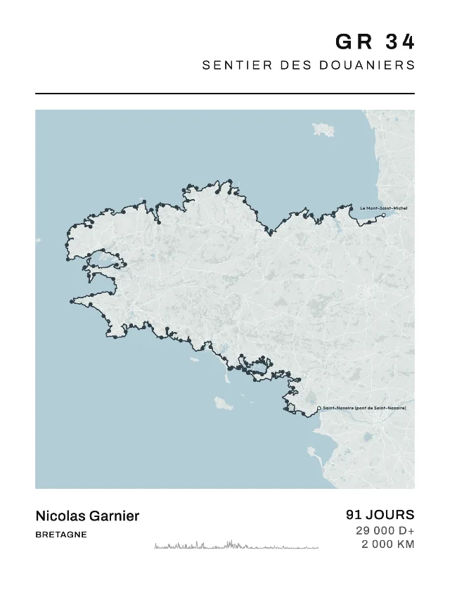
The classic stages
The stage ends, in walking order: each one is a dot on the poster.
- Stage 1Le Mont-Saint-Michel → Saint-Broladre
- Stage 2Saint-Broladre → Cancale
- Stage 3Cancale → La Guimorais (Saint-Coulomb)
- Stage 4La Guimorais (Saint-Coulomb) → Saint-Malo
- Stage 5Saint-Malo → Lancieux
- Stage 6Lancieux → Saint-Cast-le-Guildo
- Stage 7Saint-Cast-le-Guildo → Le Petit Trécelin (Plévenon)
- Stage 8Le Petit Trécelin (Plévenon) → Sables-d’Or-les-Pins (Fréhel)
- Stage 9Sables-d’Or-les-Pins (Fréhel) → Pléneuf-Val-André
- Stage 10Pléneuf-Val-André → Hillion
- Stage 11Hillion → Saint-Laurent-de-la-Mer (Plérin)
- Stage 12Saint-Laurent-de-la-Mer (Plérin) → Saint-Quay-Portrieux
- Stage 13Saint-Quay-Portrieux → Bréhec (Plouézec)
- Stage 14Bréhec (Plouézec) → Paimpol
- Stage 15Paimpol → Lézardrieux
- Stage 16Lézardrieux → Le Québo (Pleubian)
- Stage 17Le Québo (Pleubian) → Tréguier
- Stage 18Tréguier → Port-Blanc (Penvénan)
- Stage 19Port-Blanc (Penvénan) → Perros-Guirec
- Stage 20Perros-Guirec → Trégastel (Coz-Pors)
- Stage 21Trégastel (Coz-Pors) → Île-Grande (Pleumeur-Bodou)
- Stage 22Île-Grande (Pleumeur-Bodou) → Le Yaudet (Ploulec’h)
- Stage 23Le Yaudet (Ploulec’h) → Locquirec
- Stage 24Locquirec → Plougasnou
- Stage 25Plougasnou → Saint-Samson (Plougasnou)
- Stage 26Saint-Samson (Plougasnou) → Morlaix
- Stage 27Morlaix → Carantec
- Stage 28Carantec → Roscoff
- Stage 29Roscoff → Moguériec (Sibiril)
- Stage 30Moguériec (Sibiril) → Plouescat
- Stage 31Plouescat → Meneham (Kerlouan)
- Stage 32Meneham (Kerlouan) → Le Korejou (Plouguerneau)
- Stage 33Le Korejou (Plouguerneau) → Paluden (Lannilis)
- Stage 34Paluden (Lannilis) → Tréglonou
- Stage 35Tréglonou → Portsall (Ploudalmézeau)
- Stage 36Portsall (Ploudalmézeau) → Porspoder
- Stage 37Porspoder → Trézien (Plouarzel)
- Stage 38Trézien (Plouarzel) → Pointe Saint-Mathieu
- Stage 39Pointe Saint-Mathieu → Brest (Sainte-Anne-du-Portzic)
- Stage 40Brest (Sainte-Anne-du-Portzic) → Le Relecq-Kerhuon
- Stage 41Le Relecq-Kerhuon → Daoulas
- Stage 42Daoulas → Le Faou
- Stage 43Le Faou → Landévennec
- Stage 44Landévennec → Le Fret (Crozon)
- Stage 45Le Fret (Crozon) → Camaret-sur-Mer
- Stage 46Camaret-sur-Mer → Lostmarc’h (Crozon)
- Stage 47Lostmarc’h (Crozon) → Morgat (Crozon)
- Stage 48Morgat (Crozon) → Pentrez (Saint-Nic)
- Stage 49Pentrez (Saint-Nic) → Douarnenez
- Stage 50Douarnenez → Beuzec-Cap-Sizun
- Stage 51Beuzec-Cap-Sizun → Pointe du Raz
- Stage 52Pointe du Raz → Audierne
- Stage 53Audierne → Penhors (Pouldreuzic)
- Stage 54Penhors (Pouldreuzic) → Pointe de la Torche
- Stage 55Pointe de la Torche → Le Guilvinec
- Stage 56Le Guilvinec → Loctudy
- Stage 57Loctudy → Sainte-Marine (Combrit)
- Stage 58Sainte-Marine (Combrit) → Beg-Meil (Fouesnant)
- Stage 59Beg-Meil (Fouesnant) → Concarneau
- Stage 60Concarneau → Raguenez (Névez)
- Stage 61Raguenez (Névez) → Pont-Aven
- Stage 62Pont-Aven → Bélon (Moëlan-sur-Mer)
- Stage 63Bélon (Moëlan-sur-Mer) → Doëlan (Clohars-Carnoët)
- Stage 64Doëlan (Clohars-Carnoët) → Guidel-Plages
- Stage 65Guidel-Plages → Larmor-Plage
- Stage 66Larmor-Plage → Riantec
- Stage 67Riantec → Erdeven
- Stage 68Erdeven → Penthièvre (Saint-Pierre-Quiberon)
- Stage 69Penthièvre (Saint-Pierre-Quiberon) → Carnac
- Stage 70Carnac → Saint-Philibert
- Stage 71Saint-Philibert → Locmariaquer
- Stage 72Locmariaquer → Auray
- Stage 73Auray → Baden
- Stage 74Baden → Arradon
- Stage 75Arradon → Vannes
- Stage 76Vannes → Port-Anna (Séné)
- Stage 77Port-Anna (Séné) → Noyalo
- Stage 78Noyalo → Sarzeau
- Stage 79Sarzeau → Le Logeo (Sarzeau)
- Stage 80Le Logeo (Sarzeau) → Port-Navalo (Arzon)
- Stage 81Port-Navalo (Arzon) → Saint-Gildas-de-Rhuys
- Stage 82Saint-Gildas-de-Rhuys → Le Tour-du-Parc
- Stage 83Le Tour-du-Parc → Ambon
- Stage 84Ambon → Billiers
- Stage 85Billiers → Barrage d’Arzal
- Stage 86Barrage d’Arzal → Pont-Mahé (Assérac)
- Stage 87Pont-Mahé (Assérac) → Quimiac (Mesquer)
- Stage 88Quimiac (Mesquer) → La Turballe
- Stage 89La Turballe → Le Croisic
- Stage 90Le Croisic → Pornichet
- Stage 91Pornichet → Saint-Nazaire (pont de Saint-Nazaire)
Map My Life is not affiliated with the managers of this trail. Its name refers to its route; the poster is drawn by us from the route, on an OpenStreetMap base.
Sections
The parts people also walk on their own.
- Baie du Mont-Saint-MichelLe Mont-Saint-Michel → Cancale · 2 days
- Côte d’ÉmeraudeCancale → Sables-d’Or-les-Pins (Fréhel) · 6 days
- Côte de GoëloSaint-Laurent-de-la-Mer (Plérin) → Paimpol · 3 days
- Côte de Granit RoseTréguier → Le Yaudet (Ploulec’h) · 5 days
- Baie de MorlaixLocquirec → Roscoff · 5 days
- Côte des LégendesPlouescat → Le Korejou (Plouguerneau) · 2 days
- Pays des AbersLe Korejou (Plouguerneau) → Portsall (Ploudalmézeau) · 3 days
- Pays d’IroisePortsall (Ploudalmézeau) → Brest (Sainte-Anne-du-Portzic) · 4 days
- Presqu’île de CrozonLe Faou → Pentrez (Saint-Nic) · 6 days
- Cap Sizun et Pointe du RazDouarnenez → Audierne · 3 days
- Pays bigoudenAudierne → Sainte-Marine (Combrit) · 5 days
- Presqu’île de QuiberonErdeven → Penthièvre (Saint-Pierre-Quiberon) · 1 day
- Golfe du MorbihanLocmariaquer → Port-Navalo (Arzon) · 9 days
- Presqu’île de RhuysPort-Navalo (Arzon) → Le Tour-du-Parc · 2 days
- Presqu’île guérandaiseQuimiac (Mesquer) → Saint-Nazaire (pont de Saint-Nazaire) · 4 days
- A4: €40 · 30 × 40: €50 · 50 × 70: €60
- Framed
- A4: €75 · 30 × 40: €85
- Delivery
- Delivery €4.90 for prints, €7.90 with a frame, once per order, VAT included.
What you get.
200 gsm matt paper
A thick paper with no glare: your map reads as well up close as from across the room.
Printed at up to 300 dpi
The print file keeps every pass and every street sharp. What you see in the preview is what gets printed.
Ready to hang
A smooth black, smooth white or solid natural pine frame, under acrylic glass: it goes on the wall as soon as the parcel is open.
Ships within 4 working days
With you within 8 working days in mainland France, 8 to 16 elsewhere in Europe, 8 to 15 in the rest of the world and 15 to 27 in the French overseas territories.
Delivery from €4.90
Delivery €4.90 for prints, €7.90 with a frame, once per order. We deliver to the whole European Union, Monaco, Switzerland, Norway, Iceland, the United Kingdom, the United States, Canada, Australia, New Zealand, Japan, Singapore, La Réunion, Guadeloupe and Martinique.
A real person replies
A question, a route to check: write to contact@mapmylife.fr.
More hikes
Before you order.
Another question? Write to us at contact@mapmylife.fr and a real person will reply.
What does it look like printed?
The preview is the poster: same drawing, same layout, shown at 30 × 40 (at A4 and 50 × 70, a little more or a little less paper at the top and bottom). The print file is made at up to 300 dpi, on 200 gsm matt paper. On a phone, a 50 × 70 comes down to around 175 dpi: for that size, order from a computer instead. A hike can also be turned to landscape: the map takes the whole width, the same shape at every size.
What about the free PDF?
It’s your poster in A4, to print at home, with our small logo at the foot of the page. Leave your e-mail and we’ll send you the link, valid for 30 days. For personal use: print it, share it, don’t sell it.
How much is delivery, and how long does it take?
€4.90 for prints, €7.90 as soon as there’s a framed print, €15.90 to La Réunion, the French Antilles and Iceland, once per order, however many posters. Ships within 4 working days, delivered within 8 working days in mainland France, 8 to 16 elsewhere in Europe, 8 to 15 in the rest of the world and 15 to 27 in the French overseas territories.
Can I order several posters?
Yes: add them to your basket one by one, up to 10, and pay for them all at once. They all go to the same address, and delivery is paid once. A gift card is entered in the basket.
Where do you deliver?
To the whole European Union, Monaco, Switzerland, Norway, Iceland, the United Kingdom, the United States, Canada, Australia, New Zealand, Japan, Singapore, La Réunion, Guadeloupe and Martinique. Anywhere else, French Guiana, Mayotte and New Caledonia included, write to us before you order: we’ll look at shipping with you. In La Réunion, the French Antilles, Japan, Iceland and the Canary Islands, local taxes may be asked on delivery.
It’s a gift, and I don’t know their time.
Give a gift card: it arrives by e-mail in a minute, and they make their poster with their race, their name and their time.
What happens to my GPS track?
Your file stays in your browser: the poster is drawn on your device. For a print, only the poster’s final file is sent to us. If you ask for the free PDF or make a custom request, we keep the simplified shape of your route for 30 days, with no times and no health data, so you can get the same poster back. For the free PDF, your e-mail address and the poster’s settings (race, style, text, without the route) are then kept for 3 years.