GR 10 stages
GR 10 stages: crossing the Pyrenees, section by section
GR 10 stages: 922 km and 55,000 m of climbing from Hendaye to Banyuls, in six sections, 50 to 60 days. Season, huts, trains, and splitting it over summers.

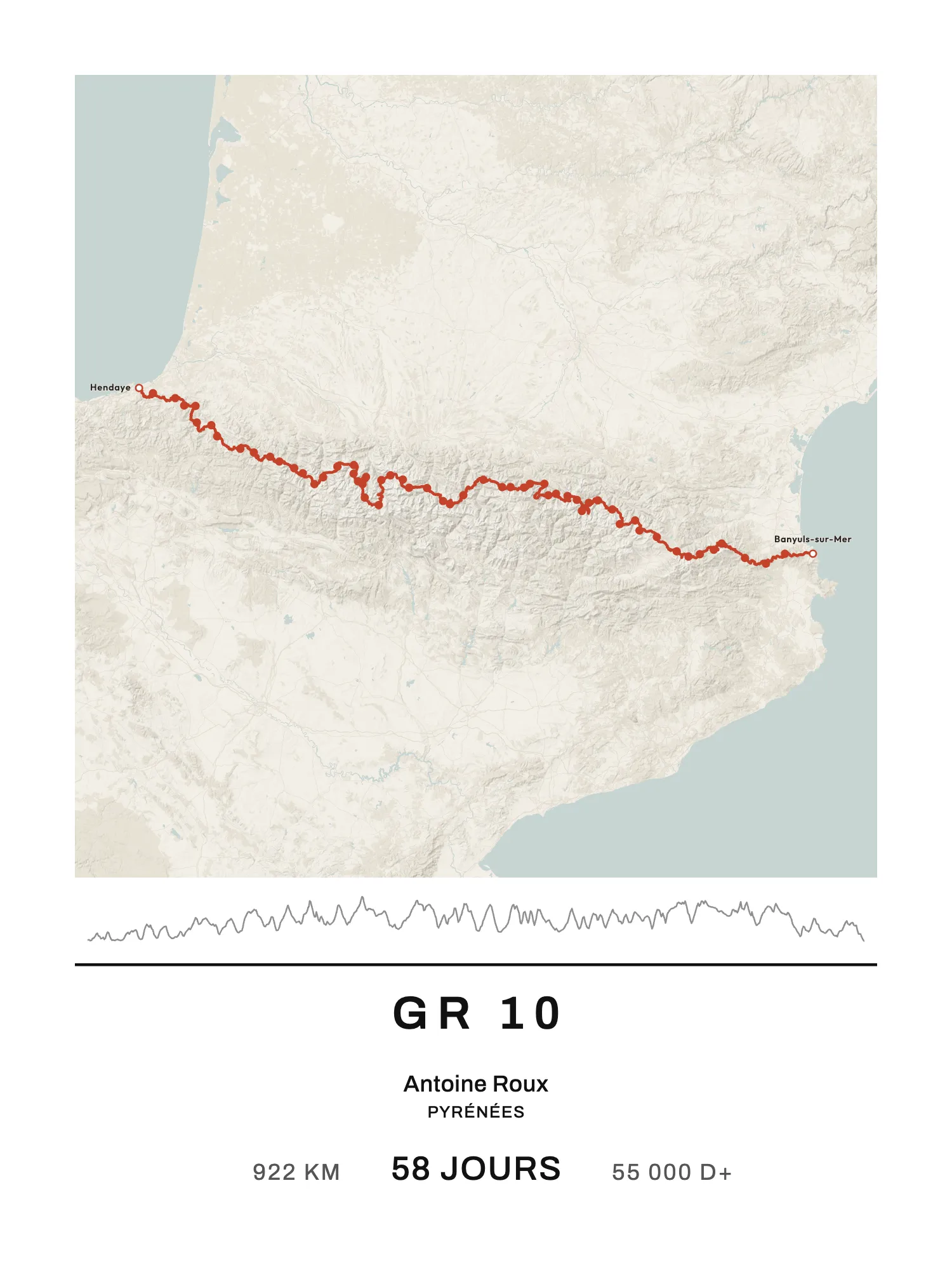
The GR 10 crosses the whole Pyrenees on the French side, from the Atlantic to the Mediterranean: from Hendaye, on the Spanish border, to Banyuls-sur-Mer. The FFRandonnée (the French hiking federation) gives 922 km and 55,000 m of elevation gain (D+, the total climbing), which means 50 to 60 days of walking. It is usually described and walked from west to east.
Many don't walk it in one go: they cut it into pieces of one or two weeks and come back summer after summer. Here are its six main sections, with the days, distance and climbing of each, then what you need to know to plan it.
The GR 10 in six sections
The catalogue's division has 58 stages, taken from Randozone. It isn't an official one: the FFRandonnée says 50 to 60 days, Wikipedia 45 to 60, and every guidebook places its stage ends a little differently. The distance and climbing per section are measured on our trace, then scaled to the official 922 km and 55,000 m: treat them as orders of magnitude, not guidebook figures.
| Section | From → to | Days | km (approx.) | D+ (approx.) |
|---|---|---|---|---|
| Basque Country | Hendaye → Sainte-Engrâce | 10 | 180 | 8,700 m |
| Béarn | Sainte-Engrâce → Gourette | 6 | 85 | 6,100 m |
| Hautes-Pyrénées (Bigorre) | Gourette → Loudenvielle | 13 | 165 | 9,700 m |
| Luchonnais (Haute-Garonne) | Loudenvielle → Fos | 3 | 55 | 3,800 m |
| Ariège | Fos → Refuge des Bésines | 16 | 240 | 17,600 m |
| Pyrénées-Orientales | Refuge des Bésines → Banyuls-sur-Mer | 10 | 195 | 9,100 m |
On average a stage is 16 km. The figure is misleading: it's the climbing that makes the day, nearly 950 m a day on average, and over 1,000 m in Béarn and Ariège.
Basque Country: Hendaye → Sainte-Engrâce (10 days)
You set off from the seafront at Hendaye, over low green hills: Olhette, Ainhoa, Bidarray, Saint-Étienne-de-Baïgorry. You pass through Saint-Jean-Pied-de-Port, the town where pilgrims on the GR 65 arrive before crossing the Pyrenees. Then the stages lengthen towards the Iraty chalets, Logibar and Sainte-Engrâce. These are the lowest mountains on the GR 10, but the climbs keep coming: nearly 8,700 m over the section.
Béarn: Sainte-Engrâce → Gourette (6 days)
The high mountains begin. You climb to the limestone plateau of La Pierre-Saint-Martin, drop to Lescun and the Aspe valley (Borce), and go on by the Ayous hut to Gabas. It's a short section in distance, but the climbing per day goes up clearly.
Hautes-Pyrénées: Gourette → Loudenvielle (13 days)
The heart of the GR 10: Arrens-Marsous, Cauterets, the Pont d'Espagne, the Bayssellance hut, Gavarnie, Luz-Saint-Sauveur, Barèges, the Lac de l'Oule, Vielle-Aure. This is where you cross the trail's highest point, the Hourquette d'Ossoue (2,734 m), at the foot of the Vignemale.
Luchonnais: Loudenvielle → Fos (3 days)
A short section by the Lac d'Oô and Bagnères-de-Luchon, then Fos, in Haute-Garonne. Luchon makes a good place to start or finish: the Montréjeau to Luchon railway reopened in June 2025, after ten years closed.
Ariège: Fos → Refuge des Bésines (16 days)
The longest section, and the one that climbs most: about 240 km and 17,600 m of D+ on our division. According to the Ariège tourist board, it covers a quarter of the GR 10 and is known as the wildest and most isolated part, with stretches where you carry several days of water and food. Stage ends: the Refuge de l'étang d'Araing, Aulus-les-Bains, the Bassiès hut, Goulier, the Rulhe hut, Mérens-les-Vals.
Check before you go: since August 2026, after a fire, an order has closed the GR 10 between the bottom of the Bassiès lakes and the hamlet of Toutous, in Marc. The tourist board gives a detour via the Col de Saleix and down to Auzat.
Pyrénées-Orientales: Refuge des Bésines → Banyuls-sur-Mer (10 days)
The landscape changes again: the Bouillouses dam, the Cerdagne plateaus (Planès), Mantet, the Mariailles hut and the Chalet des Cortalets, on the slopes of the Canigou. Then you drop to Arles-sur-Tech, Las Illas, the Col de l'Ouillat, and the last ridges above the sea down to Banyuls-sur-Mer.
When to go
The GR 10 is mostly walked from mid-June to the end of September. Wikipedia stretches the season to the end of October depending on the weather, but much of the trail is under snow in winter and the days shorten fast in autumn.
Sleeping on the GR 10
The trail goes through villages and resorts: you sleep in hotels, gîtes d'étape (walkers' hostels) or staffed mountain huts. Book the busiest huts if you walk in July or August, especially at weekends and if you want dinner there. In Ariège, some stages are spent in a cabin or a tent, self-sufficient.
Walking it over several summers
Many hikers split the GR 10 into sections they walk over several years. The six sections above make good pieces of one to two weeks. For shorter holidays, cut pieces of three or four days that start and end in a village you can reach.
Easy ways in by train:
- Hendaye, at the start, on the TGV line from Paris-Montparnasse and Bordeaux;
- Saint-Jean-Pied-de-Port, at the end of the regional line from Bayonne;
- Luchon, from Montréjeau and Toulouse;
- Mérens-les-Vals, a halt on the Toulouse to Latour-de-Carol line, where the night train from Paris also stops;
- Banyuls-sur-Mer, at the finish, half an hour from Perpignan by regional train.
Elsewhere you'll often combine train and bus to reach the starting village.
Prefer a shorter crossing along the foothills? The GR 78, the Chemin du Piémont pyrénéen, runs from Carcassonne to Saint-Jean-Pied-de-Port. To compare with the other great crossings, see the best GR trails in France.
Your GR 10 poster
On Map My Life, the GR 10 is in the catalogue with its 58 stage ends. The poster draws the route on the map, with a dot at the end of each stage; if your stages weren't ours, you can switch the dots off.
Your section. You pick the start and finish among the stage ends, or one of the six sections in the table. The poster keeps only what you walked, with its distance and climbing. If you're walking the GR 10 over several summers, you can print one section each year, then the whole trail when you reach Banyuls.
The big figure. You choose between the number of days ("58 jours", in the trail's language) and the dates you walked. If you ran it, you can put your time instead.
Portrait or landscape. The GR 10 is much wider than it is tall: about 400 km from west to east for a hundred or so from north to south. So the poster of the whole trail opens in landscape, the paper on its side, so the map takes the whole width. A more compact section can stay portrait. Your choice.
The A4 PDF is free. A print costs €40 in A4, €50 in 30 × 40 cm and €60 in 50 × 70 cm; framed, €75 in A4 and €85 in 30 × 40 cm. Delivery €4.90 for prints, €7.90 with a frame, once per order, to the whole European Union, Monaco, Switzerland, Norway, Iceland, the United Kingdom, the United States, Canada, Australia, New Zealand, Japan, Singapore, La Réunion, Guadeloupe and Martinique. Ships within 4 working days, delivered within 8 working days in mainland France, 8 to 16 elsewhere in Europe, 8 to 15 in the rest of the world and 15 to 27 in the French overseas territories.FAQ
How many days does the GR 10 take?
50 to 60 days according to the FFRandonnée, for 922 km and 55,000 m of climbing. If you want to do it in one go, allow two months.
When is the best time for the GR 10?
From mid-June to the end of September. Wikipedia stretches it to the end of October depending on the weather; in winter, much of the trail is under snow.
Can you walk the GR 10 in several goes?
Yes, and many hikers do it that way. The main sections (Basque Country, Béarn, Hautes-Pyrénées, Luchonnais, Ariège, Pyrénées-Orientales) make good pieces for one or two weeks of holiday, with stations at Hendaye, Saint-Jean-Pied-de-Port, Luchon, Mérens-les-Vals and Banyuls.
Which is the hardest section of the GR 10?
On our division, Ariège: the longest (about 16 days) and the one with the most climbing. It's also the most isolated, with stages that call for self-sufficiency.