GR 34 Brittany coast path
GR 34 Brittany coast path: the 15 sections to walk
The GR 34 Brittany coast path: 2,000 km of coastline in 15 sections, from Mont-Saint-Michel to Saint-Nazaire. Distances, season, history, tips.

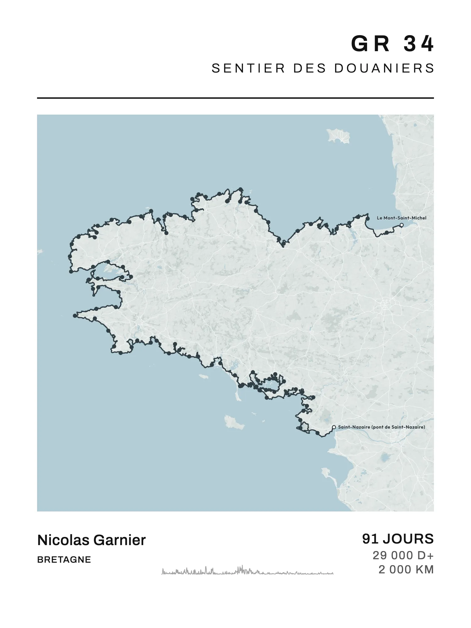
The GR 34 goes round Brittany by the coast: about 2,000 km, from the salt meadows of Mont-Saint-Michel to the Saint-Nazaire bridge. At 20 km a day, the whole of it takes about a hundred days. Most walkers do it in pieces, a weekend, a week, and come back.
Here is the trail cut into its best-known sections, with their distances, then what you need to know to walk one. In French it's the sentier des douaniers, the customs officers' path.
A customs officers' path
The path was created in 1791: customs officers patrolled it to watch the coast and stop smuggling. It fell out of use in the early 20th century. In 1968, enthusiasts reopened it and waymarked it as a long-distance trail: the first red and white marks appeared near Lannion.
It has become one of the busiest trails in France. According to a Tourisme Bretagne study of 2018, more than 9 million people use it every year: two thirds strollers, a quarter sporty walkers, and far fewer multi-day hikers. That same year, its Finistère part was voted the French public's favourite GR, with nearly 24% of 55,000 votes.
Flat? Not really
The FFRandonnée (the French hiking federation) publishes no total climb for the GR 34. It does warn that the relief "is far from flat" and that it's not unusual to climb 1,000 m in a single stage. The path drops into every cove and climbs onto every headland: short climbs, but they keep coming all day. Most of the climbing is between Mont-Saint-Michel and the Pointe du Raz; further south, the Gulf of Morbihan and the Guérande peninsula are much flatter.
The 29,000 m printed on the whole trail's poster is an estimate, not an official figure.
The GR 34 section by section
The catalogue divides the trail into 91 stages. As far as Roscoff, they follow a published walking guide. Beyond it, there is no reference division: the stage ends are placed every 15 to 30 km, at villages and places on the route. So the days and distances below are a guide only. The sections don't cover the whole trail: between them, the GR carries on (the Bay of Saint-Brieuc, the Brest roadstead, the Lorient coast…).
| Section | From → to | Days | km (approx.) |
|---|---|---|---|
| Bay of Mont-Saint-Michel | Le Mont-Saint-Michel → Cancale | 2 | 55 |
| Côte d'Émeraude | Cancale → Sables-d'Or-les-Pins | 6 | 140 |
| Côte de Goëlo | Saint-Laurent-de-la-Mer (Plérin) → Paimpol | 3 | 65 |
| Côte de Granit Rose | Tréguier → Le Yaudet | 5 | 115 |
| Bay of Morlaix | Locquirec → Roscoff | 5 | 95 |
| Côte des Légendes | Plouescat → Le Korejou (Plouguerneau) | 2 | 50 |
| Pays des Abers | Le Korejou → Portsall | 3 | 65 |
| Pays d'Iroise | Portsall → Brest (Sainte-Anne-du-Portzic) | 4 | 85 |
| Crozon peninsula | Le Faou → Pentrez | 6 | 135 |
| Cap Sizun and Pointe du Raz | Douarnenez → Audierne | 3 | 75 |
| Pays bigouden | Audierne → Sainte-Marine | 5 | 100 |
| Quiberon peninsula | Erdeven → Penthièvre | 1 | 20 |
| Gulf of Morbihan | Locmariaquer → Port-Navalo | 9 | 180 |
| Rhuys peninsula | Port-Navalo → Le Tour-du-Parc | 2 | 40 |
| Guérande peninsula | Quimiac (Mesquer) → Saint-Nazaire bridge | 4 | 95 |
The north coast: from Mont-Saint-Michel to Roscoff
You start in the bay, at the foot of the Mont, where the GR 223, the Normandy coast path from Honfleur to Mont-Saint-Michel, also ends. You reach Cancale, then the Côte d'Émeraude: the Pointe du Grouin, Saint-Malo, the Rance, Saint-Cast-le-Guildo, Cap Fréhel. After the Bay of Saint-Brieuc come the Côte de Goëlo as far as Paimpol, then the Côte de Granit Rose around Perros-Guirec and Trégastel, with its jumbles of pink rock. The Bay of Morlaix, more indented, leads to Carantec and Roscoff.
Finistère: from the Abers to the Pays bigouden
The wildest part and, with the north coast, the hilliest. The Côte des Légendes (Meneham), the Pays des Abers and its deep estuaries, the Iroise coast to the Pointe Saint-Mathieu and Brest. After the roadstead, the Crozon peninsula and its cliffs (Camaret, Morgat), then Douarnenez, Cap Sizun and the Pointe du Raz. The Pays bigouden, flatter, runs from the Pointe de la Torche to Le Guilvinec and Loctudy.
The south coast: from Concarneau to Saint-Nazaire
Flatter, with long bays: Concarneau, Pont-Aven, Lorient, then Carnac and Locmariaquer. The Gulf of Morbihan alone takes about nine days, because the path follows its whole shore, through Vannes. Then come the Rhuys peninsula, the Vilaine estuary at the Arzal dam, and the Guérande peninsula, through La Turballe and Le Croisic, to the Saint-Nazaire bridge.
About Quiberon. The GR 34 goes all the way down the Quiberon peninsula and back up. The catalogue's trace doesn't draw that: it crosses the isthmus at Penthièvre and heads on to Carnac. So the "Quiberon peninsula" section stops at Penthièvre. If you walked the peninsula, import your own GPX file in the poster builder: your own route is the one drawn.
Walking it in pieces
Pick a piece. The FFRandonnée's guidebooks (refs 345 to 348, and 561 for the Morbihan) suggest itineraries of 2 to 8 days. Tourisme Bretagne also presents the trail in stretches, such as the Côte de Granit Rose from Tréguier to Lannion, or Audierne to Bénodet.
Sleep, and carry less. Accommodation with the Rando Accueil or Étape Rando Bretagne labels will move your bags to the next stop on request, and services such as Ma Rando Facile do it too.
When to go. The GR 34 can be walked in any season. Tourisme Bretagne recommends spring, from mid-April to the end of June, and September, which is quieter. In autumn and winter, some stretches are wet or muddy.
Care on the coast. The path often runs along clifftops and sometimes crosses beaches. Stay on the waymarked route, keep away from the edge, and check the tide times when the route crosses a beach.
Want an island in a few days? The GR 340 goes round Belle-Île (83 km in four stages), 50 minutes by boat from Quiberon. The other coastal trails are in the best GR trails in France.
Your GR 34 poster
On Map My Life, the GR 34 is in the catalogue with its 91 stage ends and 15 sections. The poster draws your stretch of coast on the map, with a dot at the end of each stage.
Your section. You pick one of the sections in the table under Sections people often walk, or your own start and finish among the stage ends. The poster keeps only what you walked, with that stretch's distance. Your own stops don't match ours? Take the dots off with A dot at the end of each stage.
The big figure. The number of days, or the dates you walked. If you come back to the GR 34 every year, one poster per section makes a series: each summer, a new stretch of coast.
Portrait or landscape. The whole trail is a little wider than it is tall: it opens in landscape. A section can go whichever way suits it.
The A4 PDF is free. A print costs €40 in A4, €50 in 30 × 40 cm and €60 in 50 × 70 cm; framed, €75 in A4 and €85 in 30 × 40 cm. Delivery €4.90 for prints, €7.90 with a frame, once per order, to the whole European Union, Monaco, Switzerland, Norway, Iceland, the United Kingdom, the United States, Canada, Australia, New Zealand, Japan, Singapore, La Réunion, Guadeloupe and Martinique. Ships within 4 working days, delivered within 8 working days in mainland France, 8 to 16 elsewhere in Europe, 8 to 15 in the rest of the world and 15 to 27 in the French overseas territories.FAQ
How long does it take to walk the whole GR 34?
About a hundred days, at 20 km a day according to the FFRandonnée and Tourisme Bretagne. That's why most hikers walk it in sections, over several years.
Where does the GR 34 start and finish?
It starts in the bay of Mont-Saint-Michel and finishes at the Saint-Nazaire bridge, about 2,000 km. It can be walked in either direction.
Which section of the GR 34 should you walk first?
The best known are the Côte de Granit Rose, the Crozon peninsula and the Pointe du Raz. For easier stages, the Pays bigouden or the Gulf of Morbihan are flatter.
When should you walk the GR 34?
All year round. Spring (mid-April to the end of June) and September are the most pleasant. In autumn and winter, expect mud on some stretches.