Tour du Mont Blanc stages
Tour du Mont Blanc stages: the classic 11 days
The 11 classic stages of the Tour du Mont Blanc, anticlockwise: 170 km, 10,600 m of climbing, three countries, the passes, huts, season and getting there.

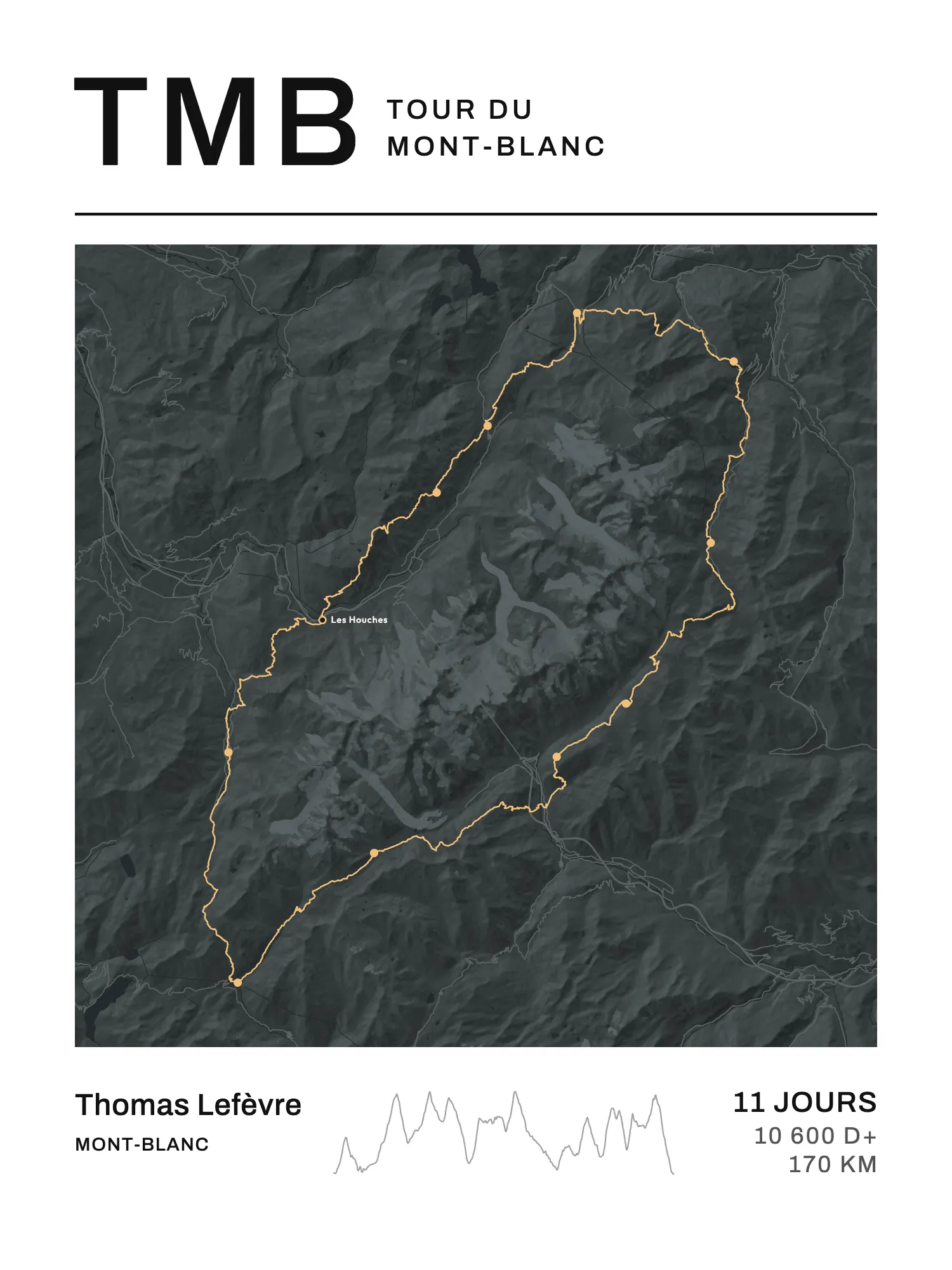
The Tour du Mont Blanc goes all the way round the massif through three countries: France, Italy and Switzerland. It's a loop of about 170 km and 10,600 m of elevation gain (D+, the total climbing), usually walked in 10 to 11 stages, from one hut or village to the next. The most common start is Les Houches, in the Chamonix valley, and the classic direction is anticlockwise: Les Contamines, into Italy over the Col de la Seigne, Courmayeur, into Switzerland over the Grand Col Ferret, Champex, then back to France over the Col de Balme.
Here are the eleven stages of that classic split, with what you need to know before you go: the passes, the huts to book, the season and how to get there.
The 11 stages in one table
The distances and climbing below come from the 11-stage Tour du Mont Blanc published by Visorando (164 km and 11,035 m of climbing in all). Its stage ends are almost the same as the classic split: it stops at Lex Blanche, just below the Rifugio Elisabetta, and in the Malatrà valley, where the Rifugio Bonatti stands. For the last two days it breaks at Lac Blanc rather than La Flégère, so we give them together. Treat these figures as orders of magnitude: depending on the variants you take, a stage can gain or lose a few kilometres and several hundred metres.
| Day | Stage | km | D+ | Key passage |
|---|---|---|---|---|
| 1 | Les Houches → Les Contamines-Montjoie | 19 | 980 m | Col de Voza |
| 2 | Les Contamines → Les Chapieux | 16 | 1,320 m | Col du Bonhomme and Col de la Croix du Bonhomme |
| 3 | Les Chapieux → Rifugio Elisabetta | 14 | 1,070 m | Col de la Seigne, French-Italian border |
| 4 | Elisabetta → Courmayeur | 15 | 520 m | long descent towards the Aosta Valley |
| 5 | Courmayeur → Rifugio Bonatti | 14 | 1,610 m | balcony above the Italian Val Ferret |
| 6 | Bonatti → La Fouly | 18 | 950 m | Grand Col Ferret, Italian-Swiss border |
| 7 | La Fouly → Champex-Lac | 17 | 670 m | Swiss Val Ferret |
| 8 | Champex-Lac → Trient | 14 | 900 m | Bovine, or the Fenêtre d'Arpette |
| 9 | Trient → Tré-le-Champ | 14 | 1,150 m | Col de Balme, back into France |
| 10–11 | Tré-le-Champ → La Flégère → Les Houches | 23 | 1,870 m | Lac Blanc, Col du Brévent |
The route, country by country
France: Les Houches to Les Chapieux (days 1 and 2)
You leave the Chamonix valley southwards over the Col de Voza, then drop down to Les Contamines-Montjoie. The second day climbs a lot: more than 1,300 m up to the Col du Bonhomme (2,329 m), then the Col de la Croix du Bonhomme (2,479 m), before coming down to Les Chapieux. Strong walkers can take the Col des Fours variant here, at 2,665 m, one of the two highest points of the tour.
Italy: Col de la Seigne to Bonatti (days 3 to 5)
The Col de la Seigne, above 2,500 m, marks the border with Italy. Beyond it you go down into the Val Veny to the Rifugio Elisabetta, then on to Courmayeur by a descent of nearly 1,500 m. The next day you climb the opposite side, above the Italian Val Ferret, along a balcony facing the massif, to the Rifugio Bonatti.
Switzerland: Grand Col Ferret to Trient (days 6 to 8)
The Grand Col Ferret (2,537 m) takes you into Switzerland. Then come two gentler days in the Swiss Val Ferret, through La Fouly, to the lake at Champex. Between Champex and Trient there are two options: the classic path over the Bovine pastures, or the Fenêtre d'Arpette (2,665 m), steeper and rockier, only for good weather.
Back to France: Col de Balme and the Chamonix balconies (days 9 to 11)
The Col de Balme brings you back to France, above the Chamonix valley. The last two days follow the balconies facing Mont Blanc, past Lac Blanc and La Flégère, then the Col du Brévent before the long descent to Les Houches: more than 2,000 m down on the last day, according to Visorando.
The huts, and how to book them
You sleep in mountain huts, gîtes, or hotels in the villages. The official platform, montourdumontblanc.com, takes online bookings for the huts and gîtes that belong to the Tour du Mont Blanc wardens' association. For the others, you contact each one directly.
Bookings for summer 2027 opened on 15 October 2026. The site advises booking as early as you can: in July and mid-August, beds go fast. June and September are more flexible, but it still advises against leaving it to the last minute.
A very busy trail. Some 80,000 hikers walk the Tour du Mont Blanc each year, according to the FFRandonnée, the French hiking federation (August 2026). Faced with the crowds, communes on the French side are studying a rule that would require every hiker to book a place in a hut or an authorised bivouac area, with checks, and would like it in force from spring 2027. As of August 2026 nothing had been adopted, and Switzerland was not planning a similar restriction. Check where the rule stands before you go.
When to go
The season runs from June to September. July and mid-August are the most sought-after periods in the huts; June and September leave a little more room, according to the official booking platform.
Getting to Les Houches
Les Houches has a station on the Saint-Gervais-Le Fayet – Vallorcine line, the Mont-Blanc Express, which serves the whole Chamonix valley. Saint-Gervais-Le Fayet is linked to Geneva by the Léman Express. Geneva airport is about 80 km away by road, with buses and shuttles to Chamonix.
Nothing says you have to start at Les Houches: it's a loop, and many people begin at Les Contamines, Courmayeur or Champex, depending on their bookings.
The tour in one go: the UTMB
At the end of August, the UTMB covers the same loop round the massif in one go, within 46 hours 30 minutes. The winners take roughly 18 to 20 hours (men) and 22 to 23 hours (women) over what hikers walk in ten or eleven days.
Keeping the loop on the wall
The Tour du Mont Blanc has a fine shape on a map: a closed loop round the massif, with all three borders inside it. On Map My Life, the Tour du Mont Blanc poster draws the whole loop and puts a dot at the end of each stage. Instead of a time, you print the number of days ("11 jours", in the trail's language) or the dates you walked.
Only walked part of it? Pick your section between two stage ends, say from Les Houches to Courmayeur: the poster draws only that piece, with its distance and climbing. Your nights didn't fall on our stage ends? Switch off "A dot at the end of each stage". The poster prints in portrait or landscape.
The A4 PDF is free. A print costs €40 in A4, €50 in 30 × 40 cm and €60 in 50 × 70 cm; framed, €75 in A4 and €85 in 30 × 40 cm. Delivery €4.90 for prints, €7.90 with a frame, once per order, to the whole European Union, Monaco, Switzerland, Norway, Iceland, the United Kingdom, the United States, Canada, Australia, New Zealand, Japan, Singapore, La Réunion, Guadeloupe and Martinique. Ships within 4 working days, delivered within 8 working days in mainland France, 8 to 16 elsewhere in Europe, 8 to 15 in the rest of the world and 15 to 27 in the French overseas territories.Looking for a present? We also put together a list of gifts for hikers. And if you're after your next long trail, the GR 20 and the other best GR trails in France are in the catalogue.
FAQ
How many stages is the Tour du Mont Blanc?
Usually 10 to 11, according to the official hut platform. The classic 11-day split starts at Les Houches and goes through Les Contamines, Les Chapieux, Elisabetta, Courmayeur, Bonatti, La Fouly, Champex, Trient, Tré-le-Champ and La Flégère.
Which direction should you walk the Tour du Mont Blanc?
The classic direction is anticlockwise from Les Houches: France, Italy, Switzerland, then back into France. Clockwise works too: you just book the huts in the other order.
Do you need to book the huts on the Tour du Mont Blanc?
Yes, especially in July and August. The association's huts are booked on montourdumontblanc.com, the others directly. For summer 2027, bookings have been open since 15 October 2026.
What is the highest point of the Tour du Mont Blanc?
On the variants, the Col des Fours (France) and the Fenêtre d'Arpette (Switzerland), both at 2,665 m. On the main route, the Col de la Seigne and the Grand Col Ferret are both above 2,500 m.